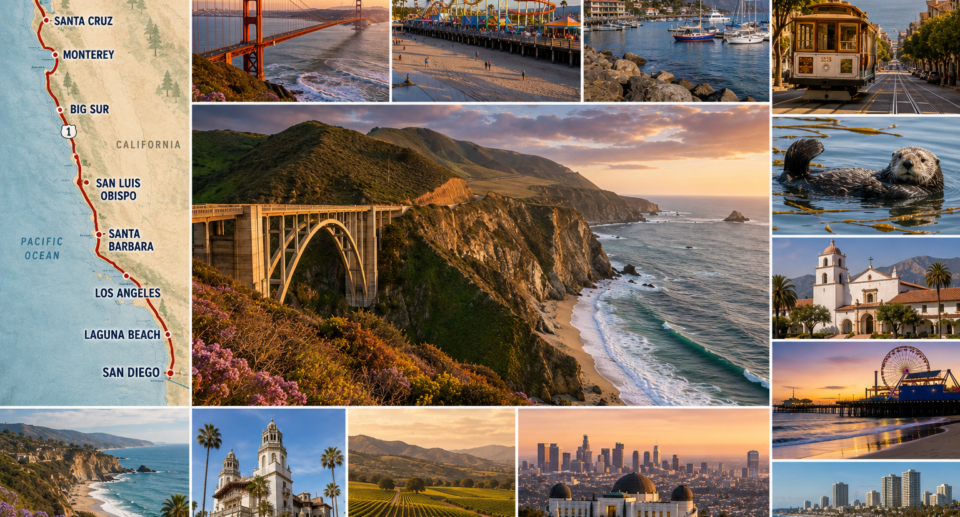
Few drives in the world compare to California’s Pacific Coast Highway. Cliffside views, redwood forests, charming beach towns, and one of the most scenic stretches of road on Earth make this a bucket-list trip. Here’s a complete itinerary for 2026.
Trip Overview
- Route: San Francisco to San Diego (or reverse)
- Distance: Approximately 500 miles
- Recommended time: 7–10 days for a relaxed pace, 5 days minimum if condensed
- Best time to go: April–June or September–October, avoiding peak summer crowds and winter storm-related road closures on Highway 1
Day 1–2: San Francisco
Spend your first two days exploring the city before hitting the road — the Golden Gate Bridge, Fisherman’s Wharf, and the winding streets of Lombard Street are essential stops. Rent your car here to begin the drive south.
Day 3: Santa Cruz & Monterey
Drive down Highway 1, stopping in Santa Cruz for its iconic beachfront boardwalk, then continue to Monterey to visit the world-class Monterey Bay Aquarium and drive the scenic 17-Mile Drive through Pebble Beach.
Day 4: Big Sur
This is the heart of the trip. Stop at Bixby Bridge for the most photographed view on the entire route, hike through Julia Pfeiffer Burns State Park to see McWay Falls dropping directly onto the beach, and take your time — this stretch of road deserves it.
Day 5: San Luis Obispo & Hearst Castle
Tour Hearst Castle, the opulent estate perched above the coastline, then continue to San Luis Obispo, a laid-back college town that makes a great overnight stop.
Day 6: Santa Barbara
Known as the “American Riviera,” Santa Barbara offers Spanish colonial architecture, excellent wineries in the nearby Santa Ynez Valley, and a walkable, palm-lined downtown.
Day 7: Los Angeles
Spend a day (or two, if time allows) exploring LA’s neighborhoods — Santa Monica Pier, Venice Beach’s boardwalk, and Griffith Observatory for sweeping city views at sunset.
Day 8: Laguna Beach & Orange County
Head south to Laguna Beach, known for its art galleries and dramatic coastal coves, a quieter alternative to LA’s busier beaches.
Day 9–10: San Diego
End your trip in San Diego, exploring Balboa Park, the historic Gaslamp Quarter, and the beaches of La Jolla and Coronado.
Practical Tips
- Check road conditions before you go. Highway 1 through Big Sur occasionally closes due to landslides — check Caltrans updates before departure.
- Book Big Sur and Santa Barbara accommodations early, especially in summer — options are limited and fill up fast.
- Fill your gas tank regularly. Stretches through Big Sur have limited gas stations and prices are notably higher.
- Download offline maps for stretches with poor cell signal, especially through Big Sur.
What to Pack
- Layers — coastal fog can make mornings cool even in summer
- A physical or offline map as backup, given patchy signal
- A good camera or phone storage — you’ll want it constantly
Frequently Asked Questions
Can this road trip be done in less than a week? Yes, a condensed 5-day version is possible by focusing on San Francisco, Big Sur, and either LA or Santa Barbara, but you’ll be moving quickly.
Is Highway 1 safe to drive? Yes, with caution — the road has sharp cliffside curves and limited guardrails in sections, so drive during daylight where possible and take your time.
What’s the best direction to drive — north to south or south to north? South to north (starting in San Diego) keeps you in the outside lane closer to ocean views, but north to south (starting in San Francisco) is more common and works equally well.
Final Thoughts
The California coast delivers some of the most dramatic scenery accessible by car anywhere in the world. Whether you have five days or ten, this route rewards travelers who are willing to slow down and pull over often — that’s where the best views are.